


Horizontal displacement monitoring method of virtual baseline with free station setting
-
摘要: 基坑监测中采用常规方法设置的基准点适用性差,传统的水平位移监测方法很难满足监测平台模块化设计和控制需求。本文分析了棱镜式基准点在城市内基坑监测中的适用性和便捷性,通过对全站仪自由设站技术的研究和应用,阐述了自由设站法建立水平位移监测独立基准网的方法步骤,并提出了提升此类基准网精度的方法,实现了对监测点相对于基准点的空间位置的精确测量。同时,提出了一种新的水平位移监测方法——基于全站仪自由设站法的水平位移监测虚拟基准线法,通过建立虚拟基准线,对监测点相对于虚拟基准线的水平距离变化进行监测,进而确定监测对象在特定方向上的位移变化,具有高精度、灵活性和实用性。Abstract: The inconvenience of using the reference point in the current foundation pit monitoring was discussed, and the applicability and convenience of the prism reference point in the urban foundation pit monitoring were analyzed. Through the research and application of the total station free station technology, the method and steps of the free station method to establish an independent reference network for horizontal displacement monitoring was introduced, and the method to improve the accuracy of this kind of reference network was proposed, to realize the accurate measurement of the spatial position of the monitoring point relative to the reference point. A new horizontal displacement monitoring method, the virtual reference line method of horizontal displacement monitoring based on the total station free setting method, is proposed. By establishing the virtual reference line, the horizontal distance change of the monitoring point relative to the virtual reference line is monitored, and then the displacement change of the monitoring object in a specific direction is determined, which has high precision, flexibility, and practicability.
-
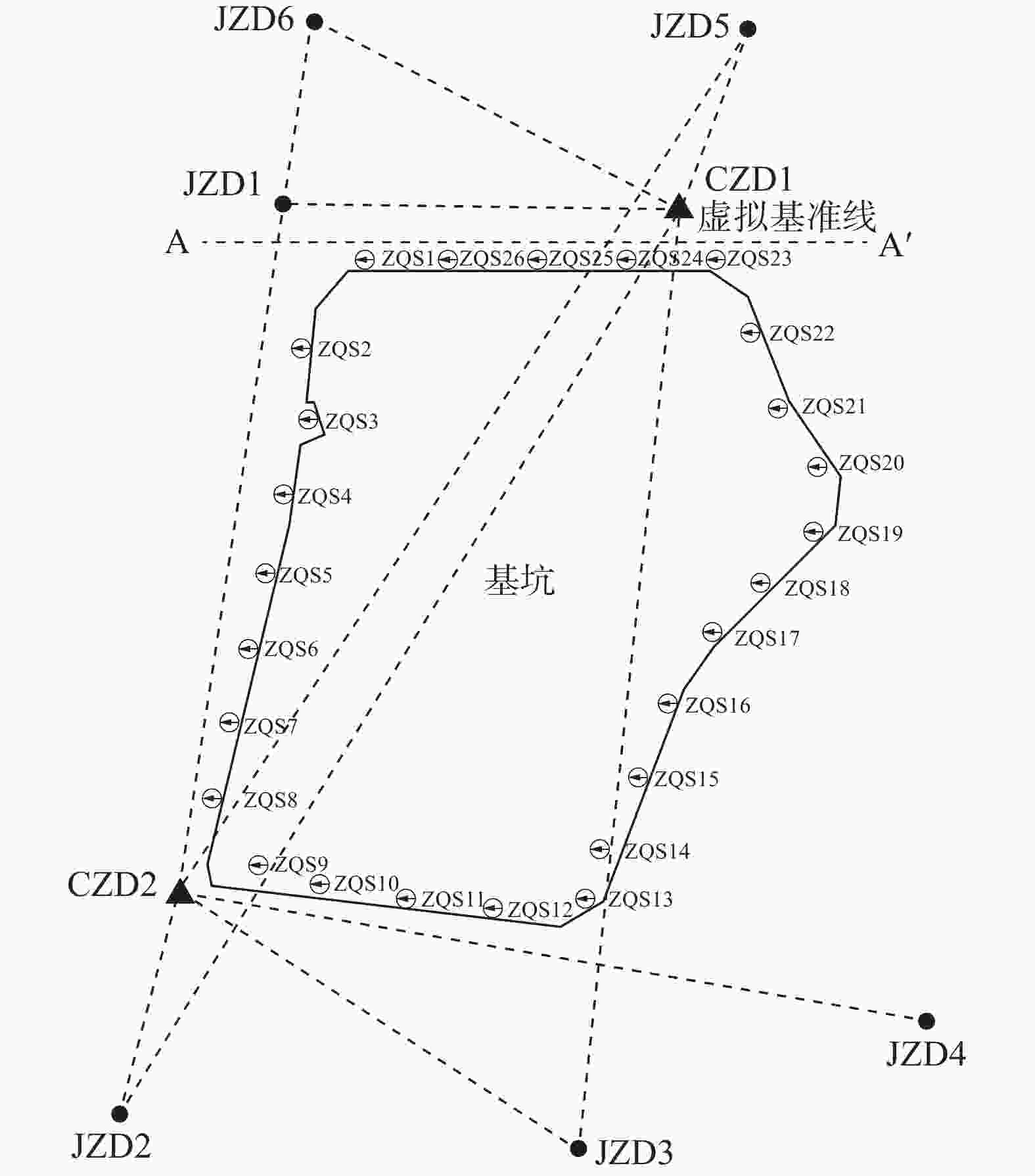
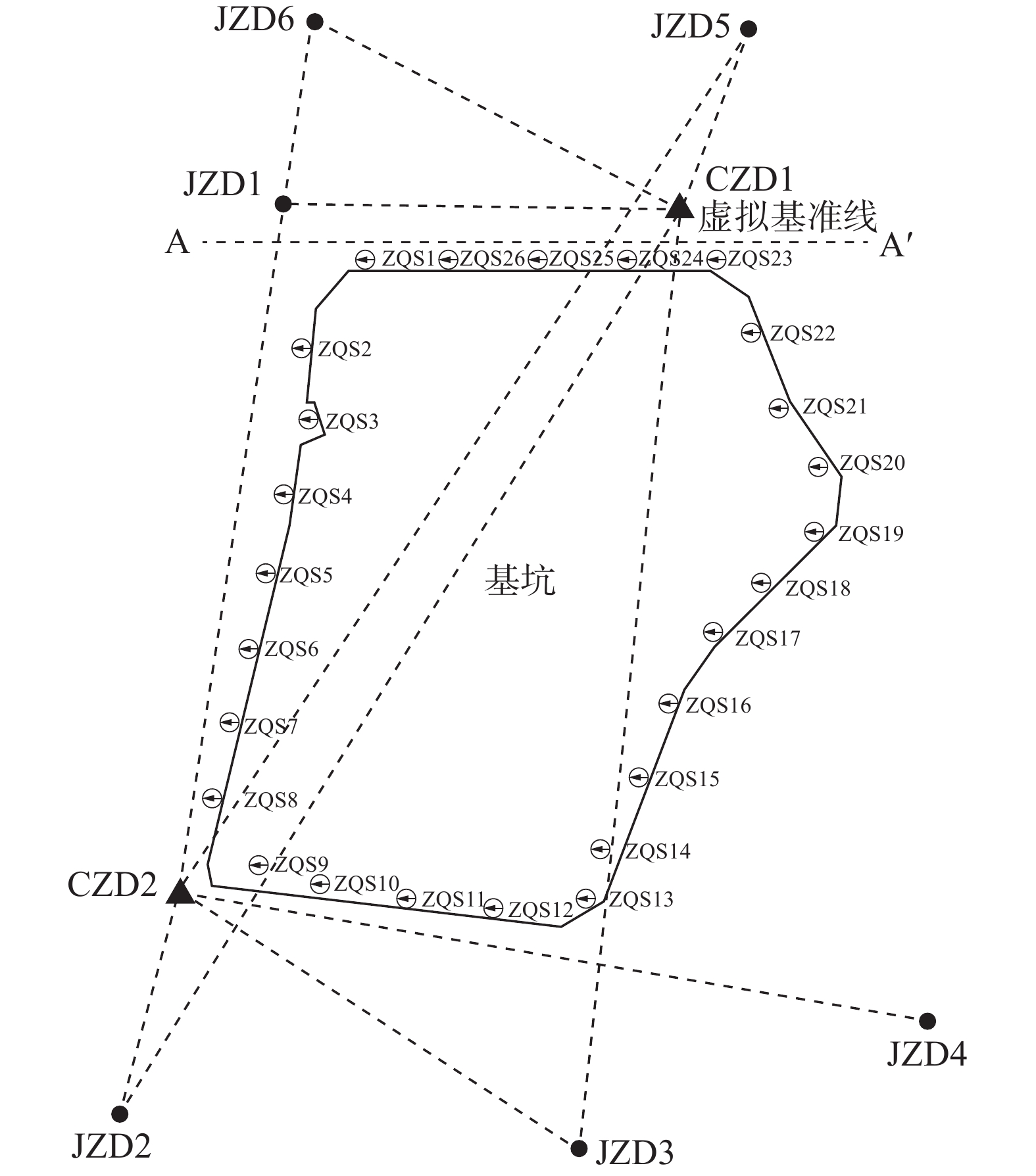
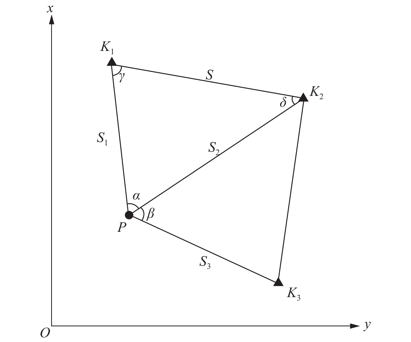
图 4 虚拟基准线法监测示意图
Figure 4. Schematic diagram of virtual reference line method monitoring
表 1 测回数对后方交会精度的影响
Table 1. Impact of the number of observation sets on the accuracy of resection
mm 工作基点点位 中误差 4测回 6测回 9测回 CZD1 2.2 1.4 1.1 CZD2 1.9 1.5 1.0  下载: 导出CSV
表 2 后方交会精度分析表
Table 2. Analysis of rear intersection accuracy
监测时间(年-月-日) CZD1 CZD2 X/m Y/m X/m Y/m 2024-06-05 2002.1387 1002.9583 2000.1577 4999.3095 2024-06-08 2002.1386 1002.9591 2000.1580 4999.3112 2024-06-11 2002.1391 1002.9605 2000.1585 4999.3112 2024-06-14 2002.1394 1002.9601 2000.1592 4999.3113 2024-06-17 2002.1403 1002.9604 2000.1589 4999.3108 2024-06-20 2002.1402 1002.9607 2000.1586 4999.3109 2024-06-23 2002.1410 1002.9620 2000.1587 4999.3107 2024-06-26 2002.1411 1002.9603 2000.1581 4999.3119 2024-06-29 2002.1414 1002.9607 2000.1586 4999.3128 2024-07-02 2002.1398 1002.9613 2000.1592 4999.3120 平均坐标 2002.1400 1002.9603 2000.1586 4999.3112 坐标中误差/mm 1.0 1.0 0.5 0.9 点位中误差/mm 1.4 1.0
下载: 导出CSV
表 3 全站仪自由设站的虚拟基准线法与视准线法成果对比
Table 3. Comparison of results between virtual reference line method and collimation line method for free stationing of total station
mm 监测时间(年-月-日) Δd ZQS2 ZQS4 ZQS5 ZQS6 ZQS7 ZQS8 ZQS9 ZQS10 ZQS11 ZQS12 2024-06-05 −0.3 −0.1 0.6 −0.1 −0.3 0.5 −0.5 0.0 0.5 0.0 2024-06-08 0.5 −0.1 −0.9 0.8 0.2 0.0 0.4 −0.3 0.3 0.3 2024-06-11 −0.3 −0.5 0.0 0.5 −0.4 −0.1 −0.4 0.5 −0.2 0.1 2024-06-14 0.0 0.1 0.4 0.1 −0.3 0.6 −0.6 −0.2 −0.7 −0.6 2024-06-17 −0.2 −0.3 0.0 0.9 0.0 −0.5 −0.4 0.2 0.7 0.4 2024-06-20 0.2 0.7 0.6 0.2 0.3 −0.3 −0.3 −0.7 0.5 −0.9 2024-06-23 0.2 −0.6 0.4 −0.9 0.0 0.5 0.7 0.1 −0.2 0.0 2024-06-26 0.5 0.0 −0.2 0.3 0.1 −0.5 −0.8 0.4 −0.3 0.5 2024-06-29 0.0 0.7 0.6 −0.3 0.1 0.3 −0.8 −0.6 0.0 0.7 2024-07-02 0.0 0.2 0.5 −0.1 0.0 0.7 −0.1 −0.4 −0.2 0.7
下载: 导出CSV
-
[1] 胡 斌, 李春华. 全站仪三维自由设站在基坑监测中的应用与分析[J]. 城市勘测, 2021(3): 177-179. (HU B, LI C H. Application and analysis of three-dimensional free station of total station in foundation pit monitoring[J]. Urban Geotechnical Investigation & Surveying, 2021(3): 177-179. (in Chinese) doi: 10.3969/j.issn.1672-8262.2021.03.042HU B, LI C H. Application and analysis of three-dimensional free station of total station in foundation pit monitoring[J]. Urban Geotechnical Investigation & Surveying, 2021(3): 177-179. (in Chinese) doi: 10.3969/j.issn.1672-8262.2021.03.042 [2] 潘 斌. 全站仪自由设站法在基坑三维形变监测中的应用[J]. 测绘与空间地理信息, 2024, 47(7): 154-156,164. (PAN B. Application of total station free station method in three-dimensional deformation monitoring of foundation pit[J]. Geomatics & Spatial Information Technology, 2024, 47(7): 154-156,164. (in Chinese) doi: 10.3969/j.issn.1672-5867.2024.07.046PAN B. Application of total station free station method in three-dimensional deformation monitoring of foundation pit[J]. Geomatics & Spatial Information Technology, 2024, 47(7): 154-156,164. (in Chinese) doi: 10.3969/j.issn.1672-5867.2024.07.046 [3] 蔡少辉. 测量机器人自由设站技术在地铁施工风险监测中的应用[J]. 铀矿地质, 2023, 39(4): 673-680. (CAI S H. Application of survey robot in risk monitoring of subway construction[J]. Uranium Geology, 2023, 39(4): 673-680. (in Chinese) doi: 10.3969/j.issn.1000-0658.2023.39.057CAI S H. Application of survey robot in risk monitoring of subway construction[J]. Uranium Geology, 2023, 39(4): 673-680. (in Chinese) doi: 10.3969/j.issn.1000-0658.2023.39.057 [4] 张瑞芳, 赵 祺. 自由设站坐标法监测基坑水平位移的精度估算[J]. 水电能源科学, 2010, 28(7): 51-53. (ZHANG R F, ZHAO Q. Precision estimation of free station coordinate method for monitoring horizontal displacement in foundation pit[J]. Water Resources and Power, 2010, 28(7): 51-53. (in Chinese) doi: 10.3969/j.issn.1000-7709.2010.07.015ZHANG R F, ZHAO Q. Precision estimation of free station coordinate method for monitoring horizontal displacement in foundation pit[J]. Water Resources and Power, 2010, 28(7): 51-53. (in Chinese) doi: 10.3969/j.issn.1000-7709.2010.07.015 [5] 梁永平, 赖国泉. 边角自由设站极坐标法在基坑变形监测中的应用研究[J]. 矿山测量, 2018, 46(1): 80-82,88. (LIANG Y P, LAI G Q. Study on the application of triangulateration free station polar-coordinate method in foundation pit deformation monitoring[J]. Mine Surveying, 2018, 46(1): 80-82,88. (in Chinese) doi: 10.3969/j.issn.1001-358X.2018.01.019LIANG Y P, LAI G Q. Study on the application of triangulateration free station polar-coordinate method in foundation pit deformation monitoring[J]. Mine Surveying, 2018, 46(1): 80-82,88. (in Chinese) doi: 10.3969/j.issn.1001-358X.2018.01.019 [6] 刘洪臣, 孙愿平, 陈 磊. 全站仪自由设站法在建筑基坑监测中的应用条件研究[J]. 岩土工程技术, 2020, 34(1): 13-17. (LIU H C, SUN Y P, CHEN L. Application conditions of total station free station method in building foundation pit monitoring[J]. Geotechnical Engineering Technique, 2020, 34(1): 13-17. (in Chinese) doi: 10.3969/j.issn.1007-2993.2020.01.003LIU H C, SUN Y P, CHEN L. Application conditions of total station free station method in building foundation pit monitoring[J]. Geotechnical Engineering Technique, 2020, 34(1): 13-17. (in Chinese) doi: 10.3969/j.issn.1007-2993.2020.01.003 [7] 王智超. 自由设站结合三维整体平差在基坑监测中的应用[J]. 测绘技术装备, 2020, 22(4): 50-53. (WANG Z C. Application of free station setting combined with three-dimensional overall adjustment in foundation pit monitoring[J]. Geomatics Technology and Equipment, 2020, 22(4): 50-53. (in Chinese) doi: 10.3969/j.issn.1674-4950.2020.04.015WANG Z C. Application of free station setting combined with three-dimensional overall adjustment in foundation pit monitoring[J]. Geomatics Technology and Equipment, 2020, 22(4): 50-53. (in Chinese) doi: 10.3969/j.issn.1674-4950.2020.04.015 [8] 赖有泉, 戴 睿, 林志鹏, 等. 自由设站边角后方交会法在深基坑变形监测中的应用研究[J]. 测绘科学与工程, 2019, 39(6): 60-64,74. (LAI Y Q, DAI R, LIN Z P, et al. Application of the method of side-angle resection method for free stations in deep excavation deformation monitoring[J]. Geomatics Science and Engineering, 2019, 39(6): 60-64,74. (in Chinese)LAI Y Q, DAI R, LIN Z P, et al. Application of the method of side-angle resection method for free stations in deep excavation deformation monitoring[J]. Geomatics Science and Engineering, 2019, 39(6): 60-64,74. [9] 严伯铎, 王宇平, 马连仲, 等. 双点边角交会法在基坑监测中的应用研究[J]. 岩土工程技术, 2023, 37(1): 13-18. (YAN B D, WANG Y P, MA L Z, et al. Application of double point linear-angular intersection in foundition pit monitoring[J]. Geotechnical Engineering Technique, 2023, 37(1): 13-18. (in Chinese) doi: 10.3969/j.issn.1007-2993.2023.01.003YAN B D, WANG Y P, MA L Z, et al. Application of double point linear-angular intersection in foundition pit monitoring[J]. Geotechnical Engineering Technique, 2023, 37(1): 13-18. (in Chinese) doi: 10.3969/j.issn.1007-2993.2023.01.003 [10] 李富荣, 刘云利, 付翔宇, 等. 基于空间基准线的水平位移监测方法探讨[J]. 测绘工程, 2016, 25(1): 55-58. (LI F R, LIU Y L, FU X Y, et al. Discussion of the horizontal displacement monitoring method based on space baseline method[J]. Engineering of Surveying and Mapping, 2016, 25(1): 55-58. (in Chinese) doi: 10.3969/j.issn.1006-7949.2016.01.013LI F R, LIU Y L, FU X Y, et al. Discussion of the horizontal displacement monitoring method based on space baseline method[J]. Engineering of Surveying and Mapping, 2016, 25(1): 55-58. (in Chinese) doi: 10.3969/j.issn.1006-7949.2016.01.013 [11] 王甫强, 余 斌. 基于虚拟中心点的水平位移监测算法研究与应用[J]. 人民长江, 2023, 54(11): 214-220. (WANG F Q, YU B. Research and application of horizontal displacement monitoring algorithm based on virtual center point[J]. Yangtze River, 2023, 54(11): 214-220. (in Chinese)WANG F Q, YU B. Research and application of horizontal displacement monitoring algorithm based on virtual center point[J]. Yangtze River, 2023, 54(11): 214-220. (in Chinese) [12] 喻 兵. 基于全站仪自由设站基准线法水平位移测量精度分析[J]. 浙江水利水电学院学报, 2018, 30(5): 45-49. (YU B. Accuracy analysis of horizontal displacement measurement based on free station datum line method of a total station[J]. Journal of Zhejiang University of Water Resources and Electric Power, 2018, 30(5): 45-49. (in Chinese) doi: 10.3969/j.issn.2095-7092.2018.05.009YU B. Accuracy analysis of horizontal displacement measurement based on free station datum line method of a total station[J]. Journal of Zhejiang University of Water Resources and Electric Power, 2018, 30(5): 45-49. (in Chinese) doi: 10.3969/j.issn.2095-7092.2018.05.009 [13] 何 荣, 崔 灿. 基于间接平差的自由设站点与监测点联合平差研究[J]. 河南理工大学学报(自然科学版), 2013, 32(3): 298-301,319. (HE R, CUI C. Combined adjustment research on free-station positioning and deformation monitor point based on the indirect observations[J]. Journal of Henan Polytechnic University (Natural Science), 2013, 32(3): 298-301,319. (in Chinese)HE R, CUI C. Combined adjustment research on free-station positioning and deformation monitor point based on the indirect observations[J]. Journal of Henan Polytechnic University (Natural Science), 2013, 32(3): 298-301,319. (in Chinese) [14] 王振方, 石俊成, 陈 伟. 一种新的基坑水平位移监测方法[J]. 北京测绘, 2015(4): 142-144. (WANG Z F, SHI J C, CHEN W. A new method of measuring the horizontal displacement of foundation pit[J]. Beijing Surveying and Mapping, 2015(4): 142-144. (in Chinese) doi: 10.3969/j.issn.1007-3000.2015.04.039WANG Z F, SHI J C, CHEN W. A new method of measuring the horizontal displacement of foundation pit[J]. Beijing Surveying and Mapping, 2015(4): 142-144. (in Chinese) doi: 10.3969/j.issn.1007-3000.2015.04.039 [15] 牟建华. 全站仪小角法基坑水平位移监测的误差分析与精度控制[J]. 城市勘测, 2019(6): 141-144. (MOU J H. Error analysis and accuracy control of the horizontal displacement monitoring of foundation pit by small angle method of total station[J]. Urban Geotechnical Investigation & Surveying, 2019(6): 141-144. (in Chinese)MOU J H. Error analysis and accuracy control of the horizontal displacement monitoring of foundation pit by small angle method of total station[J]. Urban Geotechnical Investigation & Surveying, 2019(6): 141-144. (in Chinese) -

计量
- 文章访问数: 173
- HTML全文浏览量: 96
- PDF下载量: 14
- 被引次数: 0
